


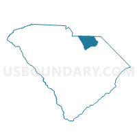
Snow Hill-Vaughn Voting District, Chesterfield County, South Carolina
About
Outline

Summary
| Unique Area Identifier | 665476 |
| Name | Snow Hill-Vaughn Voting District |
| County | Chesterfield County |
| State | South Carolina |
| Area (square miles) | 20.35 |
| Land Area (square miles) | 20.34 |
| Water Area (square miles) | 0.01 |
| % of Land Area | 99.96 |
| % of Water Area | 0.04 |
| Latitude of the Internal Point | 34.77959070 |
| Longtitude of the Internal Point | -80.08282320 |
Maps


Graphs
Select a template below for downloading or customizing gragh for Snow Hill-Vaughn Voting District, Chesterfield County, South Carolina


Neighbors
Neighoring Voting District (by Name) Neighboring Voting District on the Map
- Brocks Mill Voting District, Chesterfield County, SC
- Courthouse Voting District, Chesterfield County, SC
- Voting District GULL, Anson County, NC
- Voting District MM, Anson County, NC
- Ruby Voting District, Chesterfield County, SC
Top 10 Neighboring County Subdivision (by Population) Neighboring County Subdivision on the Map
- Chesterfield CCD, Chesterfield County, SC (7,275)
- Gulledge township, Anson County, NC (2,238)
- Morven township, Anson County, NC (2,065)
Top 10 Neighboring Unified School District (by Population) Neighboring Unified School District on the Map
Top 10 Neighboring State Legislative District Lower Chamber (by Population) Neighboring State Legislative District Lower Chamber on the Map
- State House District 69, NC (77,122)
- State House District 53, SC (34,472)
- State House District 54, SC (32,159)